


คำอธิบายของ SkyDemon
SkyDemon is one of Europe's most popular solutions for VFR flight planning and in-flight navigation.
Use this app to access your SkyDemon subscription on your Android device, unlocking SkyDemon's powerful features while on the move.
FLIGHT PLANNING FEATURES
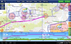
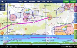
- SkyDemon vector charts are the clearest aeronautical charts you'll ever use, with dynamic airspace clipping and choice of map layers
- Route planning is as simple as touching consecutive waypoints and dragging to make changes
- Virtual Radar shows how your route relates to airspace, terrain, obstructions and other features
- Pilot Log facility calculates headings and groundspeeds from actual wind data, and shows useful frequencies
- Plates and other documents for relevant airfields are displayed automatically as you plan, and many are available georeferenced for use in flight
- Intuitive pan, pinch and rotate support with no loss of map clarity or text legibility
- File a VFR flightplan for your route directly to air traffic controllers
- Automatic TAF, METAR and SIGMET briefing as you plan a route, with graphical decoding
- Rainfall data can be overlaid on the main map, with animation, showing the trend of rainfall over time
- Integration of GAFOR route forecasts for Switzerland, Austria, Slovenia and Croatia
- Both narrow-route and area NOTAM briefings available, updated as you plan
- Advanced NOTAM graphical interpretation and depiction on the main map
- Easily print your PLOG and the output from various briefings
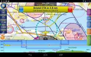
- Warnings for airspace and other potential hazards to your flight, updated in real time
- Airfield Admin Information shows useful contacts and other details for airfields featured in our charts
- Forecast winds aloft are automatically retrieved for the flight time and displayed on the map
- Create an advanced flight performance profile for each aircraft you use
- ATS Routes mode offers an alternative chart presentation for flight along airways
- Accurate fuel, weight and balance calculations including flight costings
- Create an unlimited number of user-defined waypoints
- Analyse your track logs for posterity
- Choose between six different vector chart styles
- Extensive European chart coverage as standard
GPS NAVIGATION FEATURES
- Intelligent warnings for approaching airspace, NOTAM, obstacles, terrain and other hazards
- Virtual Radar shows a side-on projection of all approaching features and how your trajectory relates to them
- Vector map automatically follows the aircraft in north up, track up or course up orientation
- Clear and concise instruments show you flight statistics and help keep you on track
- An HSI/ILS instrument helps you keep to your planned route and line up early for approach
- Live Pilot Log shows progress through your route, ETAs, ATAs and useful frequencies based on your current position
- TerrainSafe dynamically colours mountainous terrain around you to quickly identify safer areas
- Direct To allows easy re-routing in a hurry by picking from a selection of nearby airfields
- Approach Information shows runway diagrams, TAF, METAR, NOTAM and other airfield details useful for making an approach
- Live updates of TAF and METAR while in flight, with associated alerts*
- Extended runway centrelines appear automatically on the map as you near your destination airfield
- Permanent display of position relative to nearest well-known waypoint, for position reporting
- Easy changing of the planned route while in flight by touching and dragging
* Internet connection required for live weather update while in flight
SkyDemon เป็นหนึ่งในโซลูชั่นที่นิยมมากที่สุดของยุโรปสำหรับการวางแผน VFR เที่ยวบินและเที่ยวบินในการนำทาง
ใช้ app นี้เพื่อสมัครสมาชิกเข้า SkyDemon ของคุณบนอุปกรณ์ Android ของคุณปลดล็อคคุณลักษณะที่มีประสิทธิภาพของ SkyDemon ในขณะที่ย้าย
คุณสมบัติ FLIGHT วางแผน
- ชาร์ต SkyDemon เวกเตอร์เป็นที่ชัดเจนเกี่ยวกับการบินชาร์ตที่คุณเคยจะใช้กับการตัดน่านฟ้าแบบไดนามิกและทางเลือกของชั้นแผนที่
- การวางแผนเส้นทางเป็นง่ายๆเป็นสัมผัสจุดติดต่อกันและลากเพื่อให้การเปลี่ยนแปลง
- เรดาร์เสมือนแสดงให้เห็นว่าเส้นทางของคุณที่เกี่ยวข้องกับน่านฟ้าภูมิประเทศ, สิ่งกีดขวางและคุณสมบัติอื่น ๆ
- สิ่งอำนวยความสะดวกนำร่องเข้าสู่ระบบคำนวณหัวเรื่องและ groundspeeds จากข้อมูลลมที่เกิดขึ้นจริงและแสดงให้เห็นความถี่ที่มีประโยชน์
- แผ่นและเอกสารอื่น ๆ สำหรับสนามบินที่เกี่ยวข้องจะปรากฏโดยอัตโนมัติเมื่อคุณวางแผนและจำนวนมากที่มีการอ้างอิงทางภูมิศาสตร์สำหรับการใช้งานในการบิน
- กระทะที่ใช้งานง่ายหยิกและหมุนสนับสนุนกับการสูญเสียความคมชัดหรือแผนที่ความชัดเจนไม่มีข้อความ
- ยื่น Flightplan VFR สำหรับเส้นทางของคุณโดยตรงกับการควบคุมจราจรทางอากาศ
- TAF อัตโนมัติ METAR และ SIGMET การบรรยายสรุปที่คุณวางแผนเส้นทางที่มีการถอดรหัสแบบกราฟิก
- ข้อมูลปริมาณน้ำฝนที่สามารถวางทับบนแผนที่หลักที่มีภาพเคลื่อนไหวที่แสดงให้เห็นแนวโน้มของปริมาณน้ำฝนในช่วงเวลา
- บูรณาการของการคาดการณ์เส้นทาง GAFOR สำหรับวิตเซอร์แลนด์, ออสเตรีย, สโลวีเนียและโครเอเชีย
- ทั้งแคบและเส้นทาง NOTAM พื้นที่บรรยายใช้ได้ปรับปรุงตามที่คุณวางแผน
- ขั้นสูง NOTAM ตีความกราฟิกและภาพบนแผนที่หลัก
- ได้อย่างง่ายดายพิมพ์ PLOG และผลลัพธ์จากการบรรยายต่างๆของคุณ
- ข้อควรระวังสำหรับน่านฟ้าและอันตรายที่อาจเกิดขึ้นอื่น ๆ เพื่อให้เที่ยวบินของคุณปรับปรุงในเวลาจริง
- สนามบินข้อมูลดูแลระบบจะแสดงรายชื่อที่มีประโยชน์และรายละเอียดอื่น ๆ ที่โดดเด่นในสนามบินชาร์ตของเรา
- การพยากรณ์ลม Aloft จะถูกดึงโดยอัตโนมัติเวลาเที่ยวบินและแสดงบนแผนที่
- สร้างรายละเอียดผลการดำเนินงานการบินขั้นสูงสำหรับเครื่องบินแต่ละคุณใช้
- โหมด ATS เส้นทางมีการนำเสนอแผนภูมิทางเลือกสำหรับเที่ยวบินของสายการบินพร้อม
- น้ำมันเชื้อเพลิงที่ถูกต้องน้ำหนักและความสมดุลรวมทั้งการคำนวณต้นทุนการเที่ยวบิน
- สร้างได้ไม่ จำกัด จำนวนจุดที่ผู้ใช้กำหนด
- วิเคราะห์บันทึกการติดตามของคุณสำหรับลูกหลาน
- เลือกที่แตกต่างกันระหว่างหกรูปแบบเวกเตอร์แผนภูมิ
- กว้างขวางคุ้มครองแผนภูมิยุโรปเป็นมาตรฐาน
GPS นำทางคุณสมบัติ
- คำเตือนอัจฉริยะสำหรับน่านฟ้าใกล้ NOTAM อุปสรรคภูมิประเทศและอันตรายอื่น ๆ
- เรดาร์เสมือนที่ยื่นแสดงด้านบนของคุณสมบัติที่ใกล้เข้ามาทุกวิถีและวิธีการของคุณเกี่ยวข้องกับพวกเขา
- แผนที่เวกเตอร์โดยอัตโนมัติดังนี้อากาศยานในภาคเหนือขึ้นติดตามขึ้นหรือหลักสูตรปฐมนิเทศขึ้น
- ตราสารที่ชัดเจนและรัดกุมแสดงสถิติเที่ยวบินและช่วยให้คุณในการติดตาม
- ตราสาร HSI / ILS ช่วยให้คุณสามารถที่จะวางแผนเส้นทางและสายของคุณขึ้นต้นสำหรับวิธีการ
- ถ่ายทอดสดนำร่องเข้าสู่ระบบแสดงให้เห็นถึงความคืบหน้าผ่านเส้นทางของคุณ ETAs, ATAs และความถี่ที่มีประโยชน์ขึ้นอยู่กับตำแหน่งปัจจุบันของคุณ
- TerrainSafe สีแบบไดนามิกภูมิประเทศที่เป็นภูเขารอบ ๆ ตัวคุณได้อย่างรวดเร็วระบุพื้นที่ที่ปลอดภัย
- โดยตรงเพื่อช่วยให้ง่ายอีกเส้นทางรีบร้อนโดยการเลือกจากการเลือกของสนามบินอยู่บริเวณใกล้เคียง
- ข้อมูลเกี่ยวกับวิธีการแสดงแผนภาพรันเวย์ TAF, METAR, NOTAM และรายละเอียดที่สนามบินอื่น ๆ ที่มีประโยชน์สำหรับการทำวิธีการ
- การปรับปรุงสดของ TAF METAR และขณะที่อยู่ในเที่ยวบินที่เกี่ยวข้องกับการแจ้งเตือน *
- centrelines รันเวย์ขยายปรากฏบนแผนที่โดยอัตโนมัติในขณะที่คุณอยู่ใกล้กับสนามบินปลายทางของคุณ
- จอแสดงผลถาวรจากตำแหน่งเมื่อเทียบกับที่ใกล้ที่สุด waypoint ที่รู้จักกันดีสำหรับตำแหน่งรายงาน
- การเปลี่ยนง่ายของการวางแผนเส้นทางในขณะที่ในการบินโดยการสัมผัสและลาก
* การเชื่อมต่ออินเทอร์เน็ตที่จำเป็นสำหรับการปรับปรุงสภาพอากาศสดในขณะที่ในเที่ยวบิน
SkyDemon--เวอร์ชั่น3.16.12
(14-02-2024)SkyDemon - ข้อมูล APK
เวอร์ชั่น APK: 3.16.12แพ็คเกจ: aero.skydemon.skydemonandroidแอปในประเภทเดียวกัน
คุณอาจจะชอบ...


